The ‘Green Loop’ is a continuous cycling and walking route spanning 6.5 miles that encircles Watford town centre.
From the bustling Watford Junction to the tranquil Cassiobury Park, this route seamlessly connects key locations, serene open spaces and valued heritage sites, using the popular National Cycle Route 6, Ebury Way and a joined up network of cycle paths.
As a key part of the council’s commitment to promoting eco-friendly transportation and physical activity, the ‘Green Loop’ and cycling infrastructure in the town continues to evolve. This includes continuously looking to enhance routes across the town.
The council will continue to work with residents, Hertfordshire County Council and cycling organisations to enhance the Green Loop, so please stay in touch, join us on the journey and let us know how you found the experience.
Please help us to keep the Green Loop clean and tidy by reporting any issues to us.
Report a Street Cleansing or Parks issue
Explore the Green Loop
Explore the route and discover its key landmarks with our handy flyer and the map available below. You can also access our GPS route planner, which can be easily integrated into apps like Garmin for a seamless navigation experience, as well as our cue sheet with clear directions.
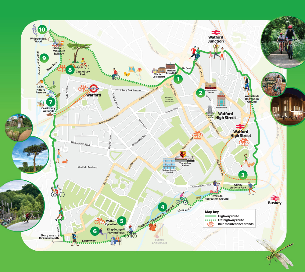
- Town Hall Quarter – The top of Watford town centre is a mixed-use cultural community hub with the Town Hall, Colosseum and Library.
- Town Centre – A bustling hub of retail, dining, entertainment as well as a rich history, it has landmarks like St. Mary’s Church, Watford’s oldest building. You can view more historic sites on Watford’s Heritage Trail.
- Oxhey Activity Park – A state of the art skate park with a café, bike trail, an adventure playground and wildflowers aimed at improving biodiversity.
- River Colne – A globally rare chalk river, the Colne’s mineral rich waters support amazing wildlife and provides a green corridor through Watford.
- Watford Parks – With many award-winning open spaces, including several along or near the Green Loop route, notable parks on the map are Waterfields and Riverside, both offering a variety of amenities. There is also King George V Playing Fields, which has Watford Cycle Hub, a children’s learn-to-ride facility, café, and fitness equipment.
- Ebury Way – A scenic route that follows the route of a disused railway line. It stretches from Rickmansworth to Watford town centre, providing a peaceful and green corridor for outdoor activities.
- Grand Union Canal – The major waterway which was originally built to transport goods during the Industrial Revolution, now offers recreational opportunities such as boating, fishing, and walking along its picturesque towpaths.
- Whippendell Wood – Recognised as ancient woodland, the scenic open space is a must-visit in spring for its for stunning bluebell displays.
- Cassiobury Park – The largest public park in Watford, it features woodland walks, a nature reserve, playgrounds, miniature railway, paddling pools, sports facilities and two cafes at the Hub and Tea Pavilion.
- Wetlands – A crucial habitat with reeds, ponds, and scrapes, as well as trees and a wildflower meadow also attracting birds like snipe and green sandpiper, as well as insects and crustaceans.
